Extratropical Cyclone Over Southern Brazil
Understanding the Phenomenon and Its Impact on Aviation
BLOGRECENTESMETEOROLOGY
12/12/202511 min read
Introduction
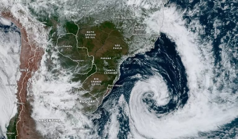
The month of December 2025 will be remembered by thousands of Brazilians, especially in the South and Southeast of the country, due to the passage of a rare and intense extratropical cyclone. The phenomenon not only caused damage in cities, with winds exceeding 120 km/h, but also triggered a cascading effect on national aviation: airports closed, flights canceled, route diversions, and passengers impacted throughout Brazil. This blog post aims to explain, in an accessible and detailed way, what an extratropical cyclone is, how it forms, its main meteorological characteristics, the specific impacts on aviation, and finally, to contextualize all of this with the recent events in southern Brazil. The text seeks to be informative both for the general public and for aviation enthusiasts and professionals, bringing updated data, real examples, and practical recommendations.
What Is an Extratropical Cyclone?
Extratropical cyclones are large-scale meteorological systems, characterized as areas of low atmospheric pressure that form outside tropical regions, usually in mid-latitudes between 30° and 60°. They are responsible for abrupt weather changes, such as strong winds, heavy rainfall, temperature drops, and in some cases, even snow. In the Southern Hemisphere, winds around the cyclone’s center rotate clockwise, while in the Northern Hemisphere they rotate counterclockwise, due to the influence of the Coriolis force, which results from Earth’s rotation.
The main energy source of an extratropical cyclone is the temperature contrast between warm and cold air masses. This contrast creates a zone of instability, where warm, moist air is forced upward, forming dense clouds and precipitation. Unlike tropical cyclones (such as hurricanes and typhoons), which have a warm core and form over warm ocean waters, extratropical cyclones have a cold core and are often associated with cold and warm fronts.
It is important to emphasize that the term “cyclone” is not synonymous with destruction. There are different types of cyclones, and their intensity and potential for damage vary depending on their structure, location, and atmospheric conditions.
How Does an Extratropical Cyclone Form?
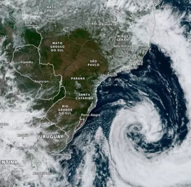
The formation of an extratropical cyclone, known as cyclogenesis, is a complex process involving the interaction of various atmospheric and oceanic factors. The starting point is an area of low atmospheric pressure, usually located between southern Paraguay, northeastern Argentina, and Rio Grande do Sul, as occurred in the December 2025 event.
The basic mechanism can be summarized in four main steps:
Creation of a low-pressure area: Warm, moist air at the surface is forced upward, usually due to the advance of a cold front or the meeting of air masses with distinct temperatures.
Divergence at altitude: At the top of the atmosphere, the ascending air spreads laterally (divergence), further reducing surface pressure.
Compensation of imbalance: The atmosphere seeks to balance the pressure difference, pulling more air into the low-pressure center, intensifying the system.
Cyclonic rotation: In the Southern Hemisphere, the Coriolis force causes winds to rotate clockwise around the cyclone’s center.
The intensity of the cyclone is directly related to the pressure difference between the system’s center and surrounding areas. The lower the central pressure, the stronger the winds and associated storms.
In extratropical cyclones, the presence of cold and warm fronts is a defining feature. The cold front, for example, pushes warm air upward, favoring the formation of cumulonimbus clouds, which can generate severe storms, hail, and even microbursts and tornadoes.
Meteorological Characteristics of Extratropical Cyclones
Extratropical cyclones present a set of meteorological characteristics that distinguish them from other types of cyclones. The main aspects are:
Structure and Core
Cold core: Unlike tropical cyclones, which have a warm core, extratropical cyclones have a cold core, influencing the dynamics of associated fronts and the distribution of instability areas.
Asymmetry: The structure of extratropical cyclones is asymmetric, with well-defined cold and warm fronts. This results in distinct weather patterns in different regions of the system.
Winds
Intense gusts: Winds can range from 64 km/h to over 120 km/h in severe events, such as the one recorded in December 2025, when gusts near 100 km/h were measured in São Paulo and over 120 km/h in southern areas.
Wind direction: In the Southern Hemisphere, winds rotate clockwise around the cyclone’s center.
Precipitation
Heavy rainfall: Extratropical cyclones are often associated with intense and heavy rainfall, with accumulations exceeding 100 mm in just a few hours, causing flooding and flash floods.
Hail and storms: The formation of cumulonimbus clouds can generate localized hail, lightning, and severe storms.
Rough seas
High waves: The cyclone’s movement over coastal areas intensifies maritime agitation, with waves reaching 3 to 4 meters, increasing the risk of storm surges and complicating port and navigation operations.
Atmospheric pressure
Low central pressure: Atmospheric pressure values below 1000 hPa are considered indicative of intense cyclones. In December 2025, values between 982 hPa and 984 hPa were recorded at the system’s center.
Associated phenomena
Tornadoes and microbursts: In extreme instability situations, tornadoes may occur, such as the one recorded in Flores da Cunha (RS), as well as microbursts, which are violent downward air discharges from storm clouds.
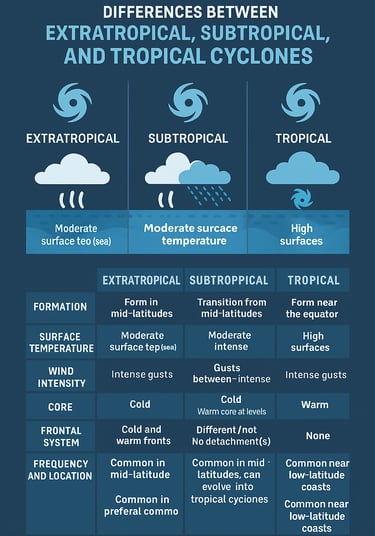
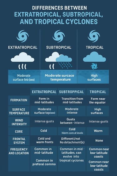
Differences Between Extratropical, Subtropical, and Tropical Cyclones
Understanding the differences between types of cyclones is essential to correctly interpret meteorological alerts and the risks associated with each phenomenon.
Extratropical cyclones are the most common in Brazil, especially in the South, and are associated with cold and warm fronts. Subtropical cyclones present intermediate characteristics, with a warm core at lower levels and a cold core at higher levels, and can evolve into tropical cyclones under favorable conditions. Tropical cyclones, known as hurricanes or typhoons in other regions, are rare along the Brazilian coast due to the need for very warm ocean waters for their formation.
Impacts of Extratropical Cyclones on Aviation
Extratropical cyclones represent one of the greatest challenges for commercial and general aviation, due to the combination of strong winds, heavy rainfall, severe turbulence, and rapid changes in weather conditions. Below, we detail the main impacts observed during the December 2025 event and in similar situations.
In-Flight Turbulence
Turbulence is one of the most feared effects by passengers and one of the main operational risk factors for pilots and crews. It can be caused by several mechanisms associated with extratropical cyclones:
Mechanical turbulence: Results from wind flow over natural obstacles (mountains, hills) or artificial ones (buildings, hangars), intensified by strong winds typical of cyclones.
Convective turbulence: Associated with the formation of cumulonimbus clouds, common in areas of instability generated by the cyclone, which can cause severe jolts and even structural damage to aircraft.
Clear Air Turbulence (CAT): Occurs at high altitudes, outside clouds, often near jet streams intensified by the cyclone. In Brazil, CAT is more frequent in winter but can occur at any time of year during extreme events.
The intensity of turbulence is classified as light, moderate, severe, and extreme. During the December 2025 cyclone, episodes of moderate to severe turbulence were reported on routes between Curitiba and Congonhas, leading to go-arounds and flight diversions.
Operational Effects of Turbulence
Discomfort and injuries: Severe turbulence can cause injuries to passengers and crew not wearing seatbelts, as well as damage to equipment and luggage.
Increased fuel consumption: Route and altitude adjustments to avoid turbulence areas can raise fuel consumption and operational costs.
Route and altitude changes: Pilots often request deviations or changes in flight level to minimize exposure to turbulence, impacting planning and operational efficiency.
Airport Operations
The effects of extratropical cyclones on airports are multiple and can seriously compromise the safety and regularity of operations:
Temporary runway closures: Winds above operational limits, low visibility, and flooding can lead to runway and terminal closures.
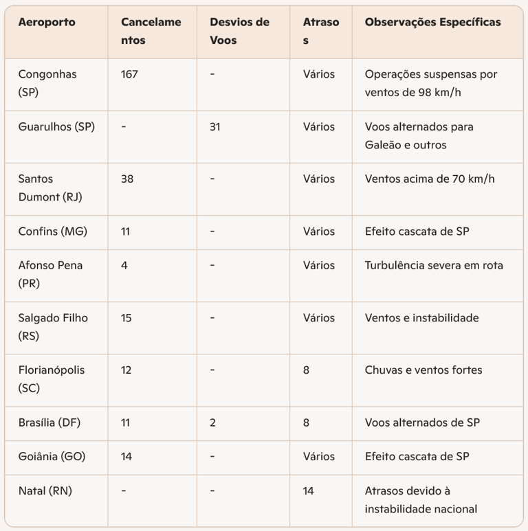
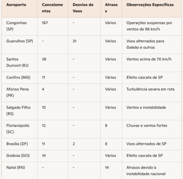
Cancellations and delays: In December 2025, Congonhas recorded 167 canceled flights in a single day, while Guarulhos had 31 flights diverted to other airports. The cascading effect impacted airports across the country, including Santos Dumont (RJ), Confins (MG), Afonso Pena (PR), Salgado Filho (RS), and others.
Aircraft diversions: Aircraft unable to land at their destination airports are diverted to secondary airports such as Viracopos, Galeão, Brasília, and Ribeirão Preto, generating congestion and overload at other terminals.
Passenger impact: The accumulation of passengers in terminals, lack of information, and the need for re-accommodation cause disruptions and losses for airlines and users.
Table – Operational Impacts at Brazilian Airports (December 2025)
(referenced as multiple cancellations, diversions, and closures across the national network.)
The data above illustrate how an extreme meteorological event can destabilize the entire national air network, requiring rapid and coordinated responses from airlines, airport operators, and regulatory agencies.
Flight Planning and Safety
Flight planning during the occurrence of extratropical cyclones requires heightened attention from operators and pilots:
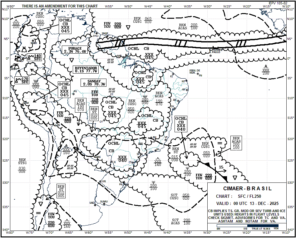
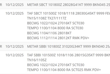
Meteorological monitoring: The use of SIGWX charts, satellite images, weather radars, and METAR/TAF reports is essential to identify risk areas and adjust routes in real time.
Emergency procedures: DECEA (Brazilian Airspace Control Department) maintains updated manuals on contingency and emergency procedures in flight, including guidance for go-arounds, diversions, and communication with air traffic control.
Crew training: Pilots and crew receive specific training to recognize and avoid adverse conditions, as well as procedures to minimize the effects of turbulence and ensure passenger safety.
Real Examples: December 2025
During the extratropical cyclone of December 2025, several incidents illustrated the challenges faced by aviation:
Severe turbulence: Passengers on a flight between Curitiba and Congonhas reported discomfort after the aircraft performed a go-around due to intense turbulence, requiring diversion to Viracopos.
Mass diversions: At Guarulhos, 31 arriving flights were diverted to alternate airports, mainly Galeão (RJ) and Brasília (DF), due to the impossibility of safe landing.
Airport closures: Congonhas was temporarily closed, with 167 flights canceled in a single day, generating queues and disruptions for thousands of passengers.
Impact on regional airports: Ribeirão Preto received five aircraft diverted from Viracopos, while Chapecó (SC) recorded three flights unable to land due to strong winds.
Contextualization: The Extratropical Cyclone in Southern Brazil in December 2025
The December 2025 event was one of the most intense ever recorded in Brazil in recent years, both in terms of the extent of the damage and its impact on aviation and urban infrastructure.
Event Timeline
December 8: Formation of the extratropical cyclone between southern Paraguay, northeastern Argentina, and Rio Grande do Sul. Heavy rainfall and strong winds hit cities in Rio Grande do Sul, with damage in at least 10 municipalities, including roof collapses, fallen trees, and flooding.
December 9: The system organizes and crosses Rio Grande do Sul, reaching Porto Alegre at night. Wind gusts exceed 100 km/h, and rainfall totals surpass 100 mm in several locations.
December 10: The cyclone reaches peak intensity, with central pressure between 982 and 984 hPa. Wind gusts of up to 98 km/h are recorded in São Paulo, causing one of the largest blackouts of the year, with more than 2 million households without power, 151 fallen trees, and the closure of parks and hospitals.
December 11: The cyclone begins to move away toward the ocean, but effects persist, with strong winds and rough seas along the South and Southeast coasts. The cascading effect on aviation continues, with cancellations and delays at dozens of airports across the country.
Meteorological Data
Rainfall: Totals between 50 and 190 mm in less than 24 hours in cities in Rio Grande do Sul, Santa Catarina, and Paraná.
Winds: Gusts between 90 km/h and 120 km/h in southern areas, with peaks of 98 km/h in São Paulo.
Tornadoes: A tornado was confirmed in Flores da Cunha (RS), with winds exceeding 100 km/h and a characteristic damage pattern, including roof collapses and destruction of structures.
Social and Economic Impacts
Energy: More than 2 million households lost power in São Paulo, affecting hospitals, schools, and essential services.
Transportation: Traffic in São Paulo reached record congestion, with 1,486 km of queues in a single day due to fallen trees and traffic lights out of service.
Aviation: Airport closures and the cascading effect of cancellations and delays impacted thousands of passengers nationwide.
Climate Change and Trends
Experts point out that although the frequency of extratropical cyclones has not increased significantly, their intensity has grown, partly due to global warming and climate change. Rising ocean and atmospheric temperatures provide more moisture and energy for the formation of more intense systems, with stronger winds and heavier rainfall.
The reduction in Antarctic sea ice extent in 2025 contributed to the intensification of the belt of extratropical cyclones, pushing these systems to lower latitudes and increasing the risk of extreme events in southern Brazil.
Modeling, Weather Forecasting, and Aviation Mitigation
Forecasting and monitoring extratropical cyclones are essential for aviation safety. Brazil has a robust numerical modeling infrastructure, using models such as COSMO, which allow for early prediction of the formation and movement of severe systems.
Forecasting Tools
Numerical models: Simulate the evolution of meteorological systems with high resolution, allowing identification of risk areas for strong winds, heavy rainfall, and turbulence.
SIGWX charts: Indicate areas of turbulence, storms, and other phenomena relevant to flight route planning.
METAR/TAF/SIGMET reports: Provide real-time information on weather conditions at airports and along routes.
Mitigation and Recommendations for Operators and Pilots
Alternative route planning: Identify alternate airports and routes that avoid higher-risk areas during cyclone passage.
Speed and altitude adjustments: Reduce indicated aircraft speed and seek flight levels with less turbulence to minimize effects.
Constant communication: Maintain contact with air traffic control and report turbulence areas to alert other aircraft.
Continuous training: Pilots and crews should be trained to recognize signs of adverse conditions and adopt emergency procedures according to DECEA and ANAC manuals.
Use of technology: Invest in onboard weather radars, automatic turbulence reporting systems (TAPS), and real-time forecasting apps to improve decision-making.
Final Considerations and Lessons from the December 2025 Event
The extratropical cyclone that hit southern Brazil in December 2025 was a clear example of the impact that extreme meteorological phenomena can have on aviation and society as a whole. The combination of strong winds, heavy rainfall, severe turbulence, and operational instability required rapid and coordinated responses from all involved in the aviation sector.
For the general public, the lesson is that events like this, although relatively common at certain times of the year, can gain intensity due to climate change, requiring attention to official alerts and understanding of the risks involved.
For aviation professionals and enthusiasts, the episode reinforces the importance of meteorological monitoring, detailed route planning, continuous training, and investment in technology to mitigate risks and ensure passenger and crew safety.
The trend is that extreme events will become more frequent and intense in the coming years, making integration between meteorology, aviation, and civil defense essential to protect lives and minimize losses. Improving forecasting models, efficient communication, and operator preparedness will be increasingly decisive in facing the challenges posed by extratropical cyclones and other severe phenomena.
In Summary
Extratropical cyclones are low-pressure systems that, when formed in mid-latitudes, can trigger strong winds, heavy rainfall, and operational instability in aviation. The December 2025 event in southern Brazil clearly illustrated how these phenomena affect not only the weather but also the routine of airports, airlines, and passengers across the country. Preparation, monitoring, and rapid response are the best tools to face these challenges and ensure safety in Brazilian skies.
Practical Tips for Passengers and Professionals
Always follow official meteorological alerts (INMET, Civil Defense, airports).
In case of a forecast of an extratropical cyclone, check your flight status in advance and be prepared for possible delays or cancellations.
Pilots and operators should review contingency procedures and maintain constant communication with air traffic control.
In turbulence situations, keep your seatbelt fastened throughout the flight, even when the sign is off.
Avoid coastal areas and open seas during the system’s peak, and follow guidance from local authorities.
Flying is safe, but respecting meteorology is fundamental to ensuring that every journey is smooth, even in the face of challenges imposed by nature.

Contact
Fale conosco para mais informações.
© 2025. All rights reserved.
About me