Microbursts: What They Are and Why They Are So Dangerous.
Explore the phenomenon of microbursts, atmospheric microexplosions that challenge both skies and cities. Learn about their impact and how they affect weather patterns and urban environments.
BLOGMETEOROLOGIAMETEOROLOGYRECENTES
12/14/202510 min read
Introduction: Explosive Winds, Surprising Impacts
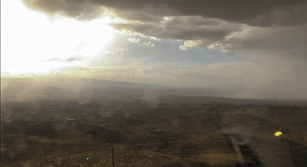
Imagine a heavy sky, dark clouds, and suddenly a gust of wind so intense that centuries-old trees fall, rooftops fly away, and even airplanes are threatened during landings and takeoffs. This is the typical scenario of an atmospheric microburst. Although less famous than a tornado, the microburst is one of the most dangerous and intriguing meteorological phenomena, especially for aviation and urban areas. In recent years, extreme events like these have become more frequent, driven by climate change and increased atmospheric instability.
In this post, we will uncover what microbursts are, how they form, why they are so dangerous, how they differ from other phenomena such as tornadoes, and what their effects are on the ground and society. At the end, you will find a glossary to make it easier to understand meteorological terms.
What Are Microbursts? Definition and Basic Concepts
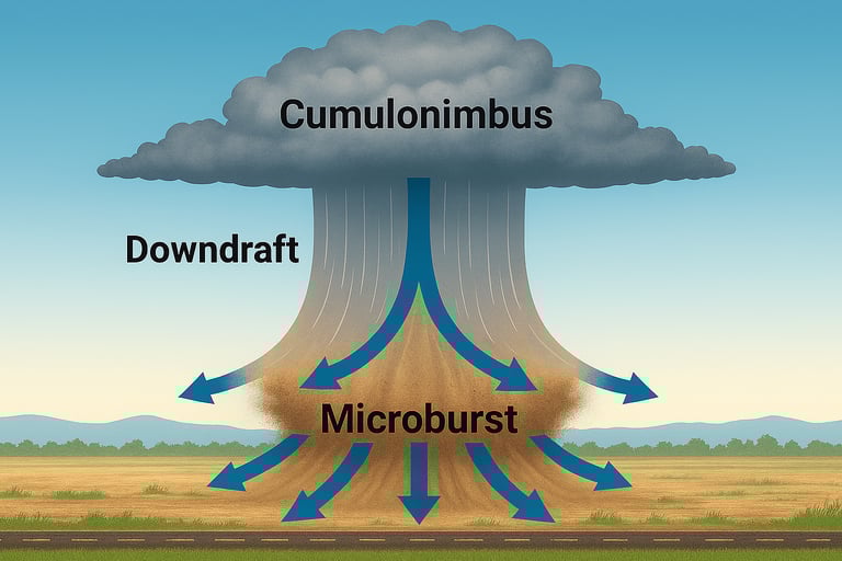
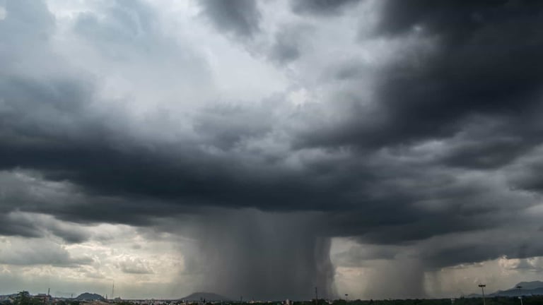
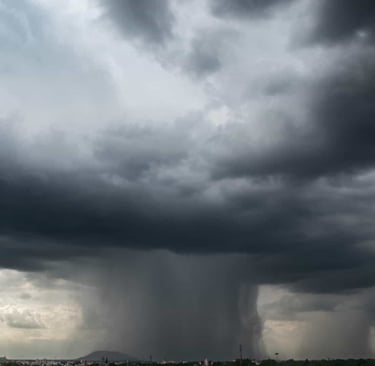
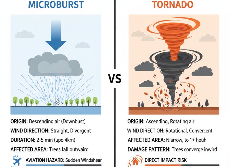
Microburst (or atmospheric microexplosion) is the name given to a violent downdraft that descends from the base of a storm cloud, hits the ground, and spreads horizontally in all directions, forming a true “wind corridor.” Despite its relatively small area of impact — usually less than 4 km in diameter — wind intensity can exceed 200 km/h, causing damage comparable to that of tornadoes or hurricanes.
The term was coined by meteorologist Tetsuya Theodore Fujita, the same scientist who created the famous tornado intensity scale. Fujita realized that many air accidents and ground damage, previously attributed to tornadoes, were in fact caused by these localized explosions of descending wind.
Main Characteristics of Microbursts:
Extremely intense and localized downdraft.
Area of impact less than 4 km in diameter (microburst); above that, it is classified as a macroburst.
Short duration: usually between 2 and 5 minutes.
Straight-line winds, without rotation, spreading radially from the point of impact on the ground.
High destructive potential, with damage to trees, buildings, and urban infrastructure.
Physical Formation Mechanisms: How a Microburst Is Born
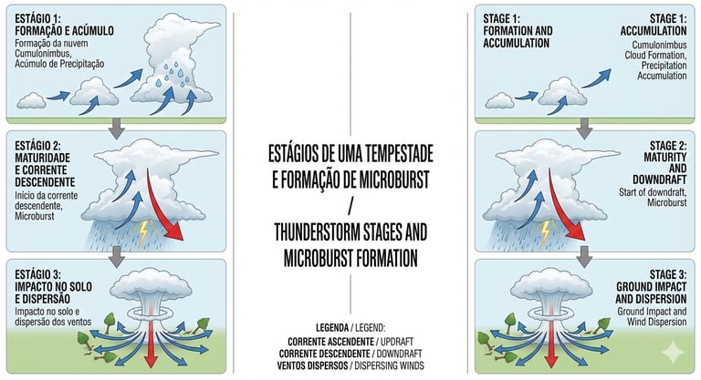
The formation of a microburst is closely linked to the dynamics of storm clouds, especially cumulonimbus clouds, known for their large vertical development and potential to generate heavy rain, hail, and lightning.
The process begins with the rise of warm, moist air which, upon reaching high altitudes, cools and condenses, forming the cloud. During the mature stage of the storm, large volumes of water and ice accumulate within the cloud. When precipitation becomes too heavy to be sustained, or when intense evaporative cooling occurs (rain evaporating as it passes through layers of dry air), a mass of cold, dense air detaches and plunges at high speed toward the ground.
Upon hitting the surface, this downdraft spreads horizontally, creating straight-line, divergent winds. The impact is so intense that it can be heard kilometers away, often described as a roar similar to that of a freight train.
Main Mechanisms Involved:
Evaporative cooling: When rain or hail passes through a layer of dry air, part of the water evaporates, cooling the air and making it denser. This cold, heavy air accelerates downward.
Precipitation loading: The weight of water and hail accumulated in the cloud can force air to descend rapidly.
Density difference: The contrast between the descending cold air and the warmer environment enhances the acceleration of the downdraft.
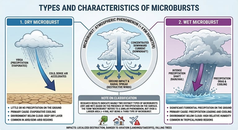
Types of Microbursts: Wet, Dry, and Heatbursts
Not every microburst is the same. Meteorologists classify microbursts into three main types, according to atmospheric conditions and the presence (or absence) of precipitation:
Wet Microburst
Occurs in environments with high humidity and is accompanied by heavy rainfall at the surface. Evaporative cooling and the weight of precipitation are the main drivers of the phenomenon. They are common in tropical regions and during summer.
Dry Microburst
Predominates in arid or semi-arid regions, where the cloud base is higher and the air near the ground is very dry. Rain evaporates before reaching the surface (virga), intensifying air cooling and accelerating the downdraft. The result is a wind explosion without significant rainfall at the surface, making the phenomenon even harder to detect visually.
Heatburst
A rare type of microburst, usually occurring at night, when a downdraft passes through an extremely dry layer of air, warming by adiabatic compression. The result is a sudden increase in temperature and drop in humidity, accompanied by strong winds. Although less common, it can cause damage and significant thermal discomfort.
Table: Types of Microbursts
It is important to highlight that the distinction between wet and dry microbursts is fundamental for forecasting and detection of the phenomenon. While wet microbursts are usually more visible due to heavy rainfall, dry ones can be surprising, as they show no clear visual signs, increasing the risk for aviation and for those in open fields.
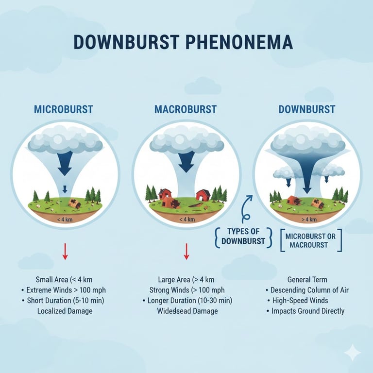
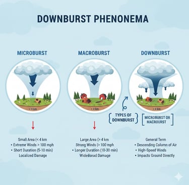
Scales and Classification: Microburst, Macroburst, and Downburst
The term downburst is used to describe any descending atmospheric explosion, subdivided according to the extent of the affected area:
Microburst: Affects an area up to 4 km in diameter, lasting 2 to 5 minutes.
Macroburst: Affects areas larger than 4 km in diameter, lasting up to 20 minutes.
Downburst: Generic term for any descending explosion, encompassing both microbursts and macrobursts.
Classification Importance
Classification is important because, although microbursts are more localized, their intensity can be just as dangerous—or even more so—than macrobursts, especially due to the difficulty of detection and the short response time available for safety measures.
Effects and Damage on the Ground and in Urban Areas
The effects of a microburst are impressive and often devastating. Upon reaching the ground, the downdraft spreads in all directions, forming a characteristic damage pattern: fallen trees pointing outward from a central point, roofs torn off, poles knocked down, and damaged structures.
In urban areas, the impacts include:
Roofs torn off houses and buildings: Winds above 100 km/h can rip off tiles and even slabs.
Fallen trees and poles: The weight of trees and the force of the winds cause obstructions in public roads, damage to vehicles, and power outages.
Flooding: Heavy rainfall in a short period can overwhelm drainage systems, causing sudden floods.
Damage to infrastructure: Bridges, power towers, traffic lights, and even metal structures can be damaged or destroyed.
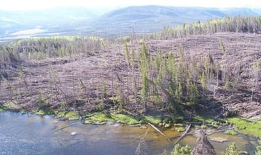
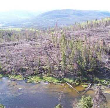
In the Amazon, microbursts have caused the fall of centuries-old trees, altering ecological balance, releasing stored carbon, and affecting food chains of animals that depend on these trees. In cities such as Maringá (PR), Araraquara (SP), and São Luiz Gonzaga (RS), recent episodes resulted in hundreds of houses losing their roofs, thousands of people without electricity, and millions in losses for the population and public authorities.
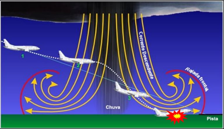
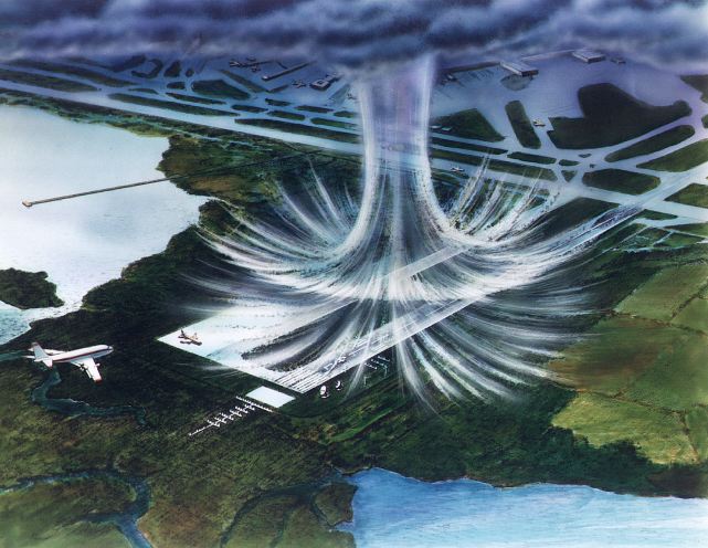
Risks for Aviation: The Invisible Enemy
Few meteorological phenomena pose such a great risk to aviation as microbursts. The danger lies in the sudden and intense change in wind direction and speed (windshear), especially during the critical phases of landing and takeoff.
When an aircraft encounters a microburst, the pilot may experience:
Strong headwind: Increases lift, leading the pilot to reduce power.
Downdraft: The aircraft rapidly loses altitude, requiring immediate response.
Sudden tailwind: Reduces lift and can lead to loss of control and impact with the ground.
This cycle can occur within seconds, leaving little time for reaction. Between the 1970s and 1980s, several fatal accidents were attributed to microbursts, including the famous Delta Flight 191 disaster in Dallas in 1985, which resulted in 137 deaths.
Since then, advances in pilot training, installation of Doppler radars, and airport alert systems have significantly reduced the number of accidents, but the risk remains, especially at airports without full detection coverage or in situations involving dry microbursts, which are harder to identify.
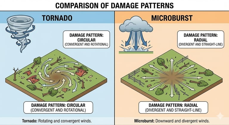
Differences Between Microbursts and Tornadoes: Understand Once and for All
Although both cause destruction, microbursts and tornadoes are distinct phenomena in their origin, structure, and damage pattern. The following table summarizes the main differences:
It is essential to highlight that, while a tornado is characterized by a rotating funnel that pulls objects toward the center, a microburst “explodes” air outward, pushing everything in a radial direction. For this reason, the destruction patterns are different: in a tornado, debris converges; in a microburst, debris diverges.
Detection, Forecasting, and Alert Technologies
Detecting and forecasting microbursts is one of the greatest challenges in operational meteorology. Because they are localized and short-lived phenomena, they often escape conventional radars and traditional alert systems.
Detection Technologies
Doppler Radar: Capable of identifying areas of wind divergence and sudden changes in airspeed. Essential at major airports.
LIDAR (Light Detection and Ranging): Uses laser beams to measure wind speed at different altitudes, increasing precision in windshear detection.
Anemometers and Weather Stations: Measure wind speed at the surface, able to record peaks associated with microbursts.
Ground Alert Systems (LLWAS): A network of sensors at airports that detect abrupt wind variations and issue alerts to pilots and controllers.
Forecasting and Limitations
Despite advances, predicting the exact location and timing of a microburst remains difficult. Meteorologists use numerical models, atmospheric instability indices (such as CAPE and DCAPE), and real-time monitoring to identify environments favorable to the phenomenon, but specific alerts are usually issued only minutes before the event.
Trends and Relationship with Climate Change
Recent studies point to a significant increase in the frequency and intensity of microbursts, especially in tropical regions such as the Amazon. Between 1985 and 2020, the occurrence of microbursts quadrupled in some areas of the forest, toppling giant trees and altering ecological balance.
Climate change, with rising temperatures and atmospheric humidity, favors the formation of more intense and unstable storm clouds, creating the perfect environment for microbursts. Once considered rare, the phenomenon has become more common and dangerous, requiring new monitoring and adaptation strategies for cities, airports, and vulnerable communities.
Mitigation and Safety Measures for Aviation and Population
Given the growing risk, it is essential to adopt mitigation and safety measures both for aviation and for the general population.
For Aviation
Pilot training: Windshear and microburst simulations are mandatory in training and refresher courses.
Onboard equipment: Modern aircraft are equipped with windshear alert systems and advanced weather radars.
Operational protocols: In case of an alert, landings and takeoffs may be suspended or diverted to alternate airports.
Efficient communication: Pilot reports and real-time information are shared among crews and controllers.
For the Population
Alert systems: Civil Defense and meteorological agencies issue warnings of storms and strong winds.
Education and preparedness: Informing the population about risks and safety procedures, such as seeking shelter away from trees and fragile structures.
Urban infrastructure: Investing in efficient drainage systems and reinforcing vulnerable structures can reduce damage caused by microbursts.
Examples and Case Studies in Brazil
Amazon Forest
Between 1985 and 2020, the frequency of microbursts quadrupled in parts of the Amazon rainforest. Extreme winds toppled centuries-old trees, altering the microclimate and releasing stored carbon, with long-term ecological and climatic impacts.
Maringá (PR)
In October 2023, a microburst struck Maringá, causing winds above 110 km/h, unroofing houses, knocking down trees, and cutting power for thousands of people. The damage pattern—trees all fallen in the same direction—helped differentiate the event from a tornado.
Araraquara (SP)
In November 2025, two microbursts within less than 48 hours produced heavy rainfall (up to 108 mm in 20 minutes), flooding, fallen trees and walls, and displaced families. The phenomenon surprised the population and required mobilization of emergency teams.
São Luiz Gonzaga (RS)
In June 2024, a microburst left more than 1,200 houses unroofed and about 15,000 people affected. The event was associated with the passage of a cold front and moisture flow from the north of the country.
Glossary of Technical Terms
Microburst: Intense and localized downdraft, with straight-line divergent winds, affecting an area up to 4 km in diameter.
Downburst: Generic term for a descending atmospheric explosion, which may be a microburst or macroburst.
Macroburst: Descending explosion affecting an area larger than 4 km in diameter.
Cumulonimbus: Storm cloud with large vertical development, origin of microbursts and tornadoes.
Windshear: Sudden change in wind direction and/or speed, dangerous for aircraft.
Virga: Precipitation that evaporates before reaching the ground, common in dry microbursts.
Heatburst: Rare microburst, characterized by a sudden increase in temperature and dry winds.
Doppler Radar: Equipment that detects particle movement in the atmosphere, essential for identifying microbursts.
LIDAR: Laser-based wind detection technology.
Straight-line winds: Non-rotational winds typical of microbursts, in contrast to the rotational winds of tornadoes.
Scientific Readings and Recommended Sources
Curitiba Climate Change Panel: Microbursts – Extreme atmospheric events in a changing climate
Climatempo: What is the difference between tornado, downburst, and microburst?
Wikipedia: Downburst – Wikipedia, the free encyclopedia
NOAA Severe Weather 101: Types of Damaging Winds
Scientific articles on microbursts and windshear in aviation: Revista Brasileira de Meteorologia
Case studies in Brazil: G1 – Microburst in Maringá
Conclusion: Microbursts – The Invisible Challenge of the 21st Century
Atmospheric microbursts are phenomena as fascinating as they are dangerous. Their ability to cause destruction in just a few minutes, combined with the difficulty of detection and forecasting, makes them one of the greatest challenges for meteorologists, pilots, urban managers, and communities. With the advance of climate change, the trend is for these events to become even more frequent and intense, requiring technological innovation, education, and continuous preparedness.
By understanding what microbursts are, how they form, and how they differ from other phenomena, we are better prepared to face their impacts and protect lives, infrastructure, and ecosystems. Stay alert to weather warnings, seek shelter during severe storms, and if you are a pilot or aviation professional, always stay updated on safety procedures.
Microbursts: small in space, giant in impact. Knowledge is the best defense.


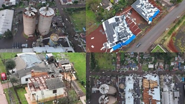
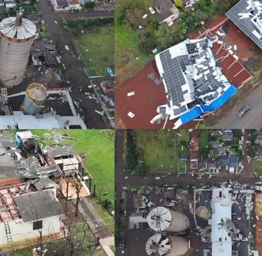
Aerial images show the damage left by "micro-explosion", a meteorological phenomenon, in São Luiz Gonzaga, in Rio Grande do Sul. (Photo: Civil Defense of RS)
Fonte: NASA.
Contact
Fale conosco para mais informações.
© 2025. All rights reserved.
About me